 |
|
|
|
PROJECTS   
Sale of Land to TxDOT
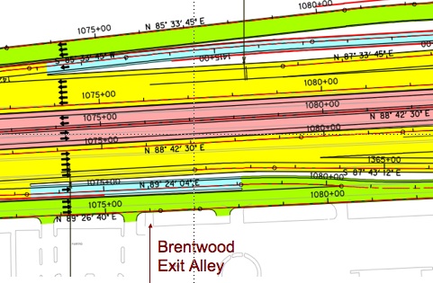
 As part of the Highway 183 expansion, the State of Texas is acquiring 11 feet of the exit alley drive via its right of eminent domain. State and local governments are authorized to purchase property for multiple purposes. If the state or local government needs a land owners private property for a public use and the landowner refuses to sell his or her property, then Texas law allows the governmental body to take the property through a condemnation proceeding. As part of the Highway 183 expansion, the State of Texas is acquiring 11 feet of the exit alley drive via its right of eminent domain. State and local governments are authorized to purchase property for multiple purposes. If the state or local government needs a land owners private property for a public use and the landowner refuses to sell his or her property, then Texas law allows the governmental body to take the property through a condemnation proceeding.

Below are milestones and documents associated with this transaction.
July 2009: The Texas Department of Transportation offered to purchase the last eleven (11) feet of the Brentwood exit alley for the Diamond Exchange expansion of Highway 183. The July 2009 offer was $2,546.00. On July 13th the Association requested an extension of the response deadline. The extension was granted.
November 2009: A special homeowners meeting was held on November 14 at 10 A.M. at 2023 Wilshire Lane, Irving, TX 75061 to vote. 70% of the homeowners voted to approve the transaction. Special thanks to Rodney Lehman and Randy Ranew for their door to door effort in collecting proxies/votes.
December 2009: After securing construction bids and meeting with the city planer, the Association countered with an offer of $26,916.00 on December 4, 2009. The States agent, Halff Associates, replied that the counter was compelling and that they will rework the offer.
February 2010: On February 3, 2010, TxDOT rescinded the offer to Beverly Oaks along with 18 other offers and put the project on hold due to budget problems. This is the second time the SH 183/Loop 12 project has been put on hold. In 2005 offers were made and rescinded. At this time 13 parcels have been purchased, 6 have been condemned, and 19 have been rescinded. We were informed that when the State decides to move forward with this project, all new appraisals would be needed.
March 2010: The Association bypasses the agent and opens a dialog with TxDOT directly (Sonya Roston, Nasser Askari, Cecil Saldana, Dan Perge, Mo Bur) on how to get the work that was done for the counter offer into the record to be reviewed before any additional offers are made. It is finally agreed that the counter proposal will be give to the appraiser before the land is appraised a second time.
January 2013: On January 4, the gent sent an offer is sent to Joe Sandifer (previous Association manager). On January 9 the board received the package - an offer of $27,342
February 2013: On February 5, the Association requested an extension of the deadline to March 29, 2013 to allow owners time to review and approval this bid by a formal vote. The extension was denied on the 14th and the Association was informed that negotiations could continue but the State's Attorney General reserved the right to litigate the matter. The Association was informed that the State was trying to close deals as quickly as possible and was granting no extensions to anyone.
March 2013: On March 15th the owner vote 96% in favor of the sale and the agent was asked to prepare papers. On March 27th board passed a resolution to sell the property. On March 28, the Association received five closing documents: Memorandum of Agreement, Deed, AP-152, Exhibit "A" to Deed, Corporate Resolution, and Partial Release of Declaration of Covenants. The Association rejected these documents on the same day and returned them for correction. Additionally, the Association requested that the ground be staked before any documents are signed so that the exact location of the property line.
April 2013: On April 12th the surveyors staked the property line. On April 15, the proposed sale documents were circulated to the homeowner's Mao Chang, Helmuth Delius, Candy Gianuzzi, Chad Johnson, Shirley Otrovodec, Randy Ranew, Vivian Scott, Kathleen Williams, an Robert Bauer for review ad comment.
May 2013: On May 2nd the sale documents are amended to guaranty that the exit alley will be connected to Highway 183.
July 2013: On April 26th the Association executed the commitment letter. Universal Land Title of Texas has been retained to serve as title company for the closing.
October 2013: On October 31st the Association signed the bill of sale and endorsed the state warrant
November 2013: On November 4th the Association closed on the sale. The net proceeds (cash payment) of $27,342.00 was deposited in the capital account.
Overview
Click photo to see larger area
Transaction Approved by Owners: A special homeowners meeting was held on November 14, 2010at 10 A.M. at 2023 Wilshire Lane, Irving, TX 75061 (the community meeting place/garages) to vote. 70% of the homeowners voted to approve the transaction. Special thanks to Rodney Lehman and Randy Ranew for their door to door effort in collecting proxies/votes.
An eballot vote was held on was held on March 15, 2013. 96% of the voters approved the sale of the land.
Requirement in Covenant and Restrictions Document: Approval of sixty-seven percent (67%) of the voters is required to do a land transaction.
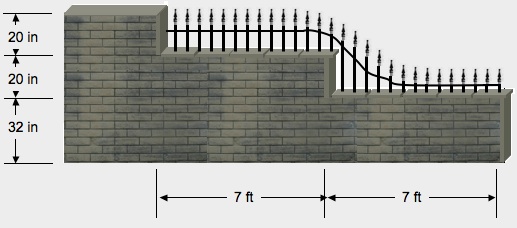
Counterproposal: The cost of renovations to the Associations exit alley once the new highway is in will exceed the $2,546 (This price per square foot is the same that is being offered to the dealerships (highest and best use). As such, the Association has asked for additional compensation to make the following changes:
| ~ |
create a cutaway on the screening wall so that exiting drivers and oncoming traffic visibility of the exiting vehicle when it is 20 foot back from the road
|
| ~ |
relocate the traffic spikes 35 feet from the roadway (enough to accommodate a pickup with a trailer),
|
| ~ |
relocate the electric sign,
|
| ~ |
relocate the power utilities, and
|
| ~ |
add additional warning signage. |
|
|
We have confirmation that our road has access to the service road ad that the ditch will be removed. Access will be included as a condition of sale.
The negotiation process only provided for us to make a single counter offer and it must be fact based and supported by drawings, quotes, etc. We had requested six 30 day extensions for gathering information, scheduling a special meeting of the owners, and to understanding the process. The last extension expired December 9, 2009. The counter was submitted on December 7th.
The counter proposal requests the relocation of the traffic spikes and modifications to the West wall so that a pickup and trailer accidently pulling onto the drive can pull completely off the road and have visibility to then back out.
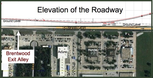
Good News: The Boards Interpretation of the drawings is that the highway will be at ground level north of the complex. We hope this is true as it would mean that we will not have immediate noise issues that affect quality of life/property values. There is no sound wall planned for this area.
It appear that the highway does not rise to housetop level until it reaches Darr Equipment. Our trees on the north and east side of the community will be important in screening the visual and the sound. There are discussions about building an outlet mall on Tom Braniff Drive but nothing had been “inked” as of today (August 2009).
Disappointment: Our access to the highways will change. The service roads will form a large box around Texas stadium land. Anyone leaving from the back community exit will be able to go in all 4 directions (north, south, east, west). The corner of the box will have traffic lights. It appears that we will have to navigate two traffic lights and drive a mile and a quarter on the service roads before we can get onto 183 eastbound (at Grauwyler) or 482 northbound.
On the north side of 183, most of the businesses will be removed from Carl to O'Connor including Taco Bell, Whataburger10/27/09, the strip center, etc.
On the south side of 183, both gas stations at Carl Road will be removed as will the Public Storage property. Mc Donalds will remain, but be altered. The dealerships will also remain.
Texas Stadium was demolished in April 2010.
Additional Information: The Diamond Interchange is $518 million expansion that will transforming how motorists maneuver through state highways 114 and 183, Loop 12 and Spur 482. Currently, motorists must exit highway or use cloverleafs to get from one highway to another. The Diamond Interchange will add direct connections to the main lanes of all the highways surrounding the stadium site.
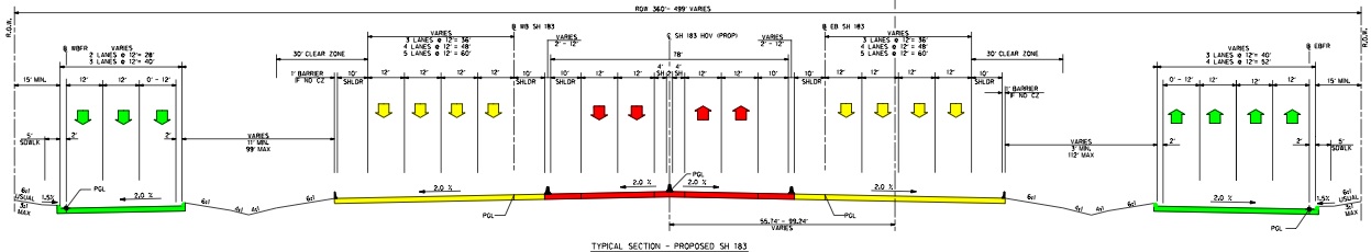
The highway will be part toll road, part freeway, part local road. In the center of the complex will be a two lane (in both directions) toll road with shoulders, guard rails, etc. (see red arrows). Outside of that will be four lane (in both directions) freeway (see yellow arrows). On the outside of that will be a 3-4 lane local service road (see green arrows).
Click photo to enlarge
The Diamond Interchange will be a “High Five” similar to that at connecting I635 and State High 75 in Richardson. From the drawings, the highest points of the highway will be just east and just south of 76 acre Texas Stadium property and appears to be as high as 90 feet. We do not think it will be visible from the community.
| TxDOT::Offer to purchase land for $2,546.00 |
|
07-2009 |
 |
| e-mail: Questions submitted to TxDOT/TxDOT answers |
|
07-2009 |
|
|
|
|
|
| e-mail: City of Irving Set Back Recommendations |
|
10-2009 |
|
|
|
|
|
| Proxy Ballot |
|
11-2009 |
|
| Association Counter offer |
|
12-2009 |
|
|
|
|
|
| TxDOT:: Offer to purchase land for $27,342 |
|
01-2013 |
|
|
|
|
|
| e-Ballot |
|
02-2013 |
|
|
|
|
|
| Closing Doc: Memorandum of Agreement |
|
03-2013 |
|
Closing Doc: Deed
|
|
03-2013 |
|
| Closing Doc: AP-152 |
|
03-2013 |
|
| Closing Doc: Exhibit "A" to Deed |
|
03-2013 |
|
| Closing Doc: Partial Release of Declaration of Covenants |
|
03-2013 |
|
| Resolution Doc: Draft from Lawyer |
|
03-2013 |
|
|
|
|
|
| Sale Doc: Memorandum of Agreement-Revised |
|
05-2013 |
|
|
|
|
|
| Sale Doc: Executed by the Board |
|
07-2013 |
|
|
|
|
|
| News: Up to the Minute Road Construction Information |
|
|
 |
| Complete Drawings of the Highway Improvements |
|
|
|
|
|
|
|
THIS PAGE WILL BE UPDATED AS ADDITIONAL INFORMATION BECOMES AVAILABLE
|
|
|